For those of you familiar with Greenprinting it will seem odd to have to submit comments to CAMPO to avoid damaging the San Marcos River.
The Capital Area Metropolitan Planning Organization’s 25 Year Transportation Plan is updated every five years with a variety of transportation infrastructure improvements mapped out for the future. It’s a good idea to plan such things, and it helps bring in federal highway, airport, bi-ped and rail funding.
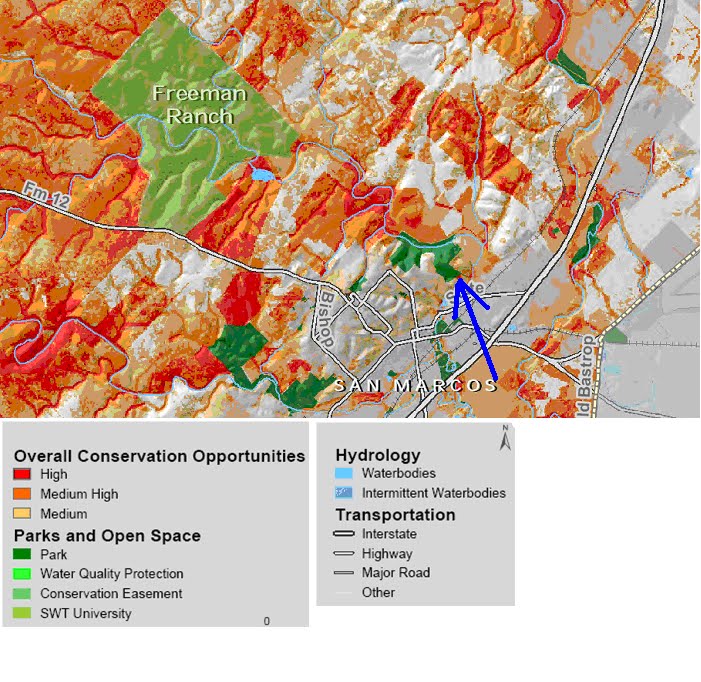
Meanwhile, the Greenprint planning process, as you may know, captured and mapped in detail natural and cultural elements that are of high and moderate value. The Greenprint for Hays County is a product of thousands of hours of public input and geographic study all plugged into the latest mapping technology. Among many advantages is the ability to know where not to put highway infrastructure. In fact, the Federal Highway Administration gave Envision Central Texas and the Trust for Public Lands thousands of dollars to help cover the $250,000 cost of the Greenprint process for the three counties. Their hope was that the information would be used in planning decisions. (see maps below)
So why didn’t CAMPO use the Greenprint to adjust their highway plan for San Marcos?
People who study these things talk about the problem of “towering” when trying to get productive dialog between environmentalists, who everday discover hitherto unrealized consequences of humanity’s clumsy progress across the countryside, and government agencies and developers, who everyday find another hurdle standing in the way of financing and constructing the roads and buildings we all use. Towering basically means that one hand does not know what the other is doing; one not talking to the other. This leads to many terrible decisions and horrible consequences that could have been avoided to the advantage of both “towers” and everyone else if only they had bothered to learn what the other has to share.
That is why we really need you to say something.
Dianne Wassenich of the River Foundation did bother to find out about the CAMPO plan, only to discover that they completely ignored the Greenprint data in relation to the San Marcos River. Their draft version of the 25 Year Transportation Plan shows an arterial roadway going directly across the area above Spring Lake and Sink Creek in order to connect IH35 to Ranch Road 12, even though the Greenprint plan shows this area to be some of the most sensitive land in Hays County. But even the Greenprint doesn’t quite capture what we all know to be common sense. The area they want to plow through is brimming with sink and karst features that, depending on the recent rainfall, are either gushing water into the creek feeding Spring Lake or are taking water into the aquifer that feeds the springs of Spring Lake. And of course all of this area is the closest portion of the watershed for the river, so many pollutants off the proposed roadway and the inevitable development that will ensue would devastate the one-of-a-kind flora and fauna of Spring Lake.
What can you do? Submit a comment telling CAMPO to amend the draft before it becomes final.
Click on the link CAMPO comment and let them know how you feel about the idea of paving over Sink Creek. You will see instructions for making a comment once you are there. You will also see a wealth of other information available about the entire plan, and you can comment on other aspects as well. Please tell them an arterial roadway that will require very expensive construction and cause irreparable damage to the river, its unique flora and fauna, and the aquifer that feeds it is a bad idea. And, let them know that their plan ignores the excellent, detailed, and collaborative work funded in part by the Federal Highway Administration. Maybe that is a tower they ought to talk to.

Here is a portion of the CAMPO map depicting the proposed arterial roadway (dotted blue line with our red arrow). Spring Lake Preserve has been colored in green to help get a sense of location for the route.
Below is a portion of the Greenprint map with an arrow pointing to Spring Lake Preserve just above Sink Creek and Spring Lake. The red area is of high value for protection and the orange moderate.